
Albion Interactive History / Albion Interactive Map / Blocks
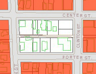
US Census Block # 34-306 (Block 51)
Interactive Map
Addition +
Plat of the Village of Albion in Calhoun County Michigan, 1836Adjacent Streets +
North – Center St, East – Clinton St, South – Porter St, West – Eaton StAdjacent Blocks +
NW 33-109, N 34-307, NE 34-308, E 34-305,SE 34-304, S 34-303, SW 33-116, W 33-116Buildings +
Center St
217
215
213
211
209
203Clinton St
212, Michigan Bell/Ameritech Building, 1948 (listed as 210 on earlier maps)
206
202Porter St
202
206
210
214
218Historical Maps +
1858 Map of Calhoun County
1866 Ruger Birdseye View
1873 Atlas of Calhoun County
1888 Sanborn Insurance Map
1893 Sanborn Insurance Map
1900 Sanborn Insurance Map
1907 Sanborn Insurance Map
1913 Sanborn Insurance Map
1918 Sanborn Insurance Map
1931 Sanborn Insurance Map
1999 City of Albion GIS
2000 Downtown Birdseye