

Visit to Cumberland, Maryland (2014)
Cumberland is at the confluence of the Chesapeake and Ohio Canal and the National Road. During the Civil War this made Cumberland an important command and control center. Today the community has an active focus on tourism and outdoor recreation.

The Chesapeake and Ohio Canal ran from Georgetown in Washington D.C. (Mile 0) to Cumberland, MD (Mile 184.5) paralleling the Potomac River. Most of the heavy shipping originated from the western terminus at Cumberland. Boatmen carrying coal, lumber, grain and cement passed through Hancock, Williamsport, Sharpsburg, the Harpers Ferry area and Branswick on their way to Washington, D.C. where their cargoes were unloaded. A one-way trip usually took 5 to 7 days.
The lifeblood of the canal was its people-the canal builders, boatsmen, locktenders, mule drivers and families who lived and worked on the canal. Days were long and the life was hard for the many people who made the canal run.
The Chesapeake towpath to “tow” the boats to and from Washington. “Packet” or passenger boats operated as well and were often pulled by horses. The canal had a series of structures for boats to pass through or over-including lift locks, a tunnel, aqueduct bridges and culverts. In addition to strong competition from the railroads, nature often threatened the canal with recurring floods of the Potomac River. A flood in the spring of 1924 closed the canal permanently for commercial shipping. Mules powered the heavy cargo boats by walking along the many people who made the canal run.
The National Road
Americans are an adventurous people. From past to present, they have used feet, horses, wagons, stagecoaches, canals, railroads, bicycles, automobiles, trucks and buses to “perpetually change their plans and abodes.” Centuries ago, George Washington dreamed of a highway joining east and west. In 1806, Thomas Jefferson made that roadway a reality when he risked his Presidency by authorizing, “an Act to regulate the laying out and making [of] a road from Cumberland in the State of Maryland to the State of Ohio.”
The next generation built that “United States Road,” a thirty-foot wide, crushed stone thoroughfare that spanned rivers, traversed mountains and opened up America’s western frontier to the Mississippi. Merchants, traders and families from all over the world journeyed along this route in their quest to claim land, expand markets and form new lives.

Cumberland in the Civil War
After stunning victories at Fredericksburg and Chancellorsville, Virginia, early in May 1863, Confederate Gen. Robert E. Lee carried the war through Maryland, across the Mason and Dixon Line and into Pennsylvania. His infantry marched north through the Shenandoah Valley and western Maryland as his cavalry, led by Gen. J.E.B. Stuart, harassed Union supply lines to the east. Union Gen. Joseph Hooker, replaced on June 28 by Gen. George G. Meade, led the Army of the Potomac from the Washington defenses in pursuit. The Federals collided with Lee’s Army of Northern Virginia at Gettysburg, Pennsylvania, on July 1, starting a battle neither side had intended to fight there. Three days later, the defeated Confederates began retreating Gen. Robert E. Lee through Maryland, retracing their steps to the Potomac River and crossing into Virginia on July 14. To follow in their footsteps and to discover their stories, stop by any Welcome Center or local Visitor Center to pick up a Gettysburg: Invasion & Retreat Civil War Trail map-guide. Please drive carefully as you enjoy the history and beauty of Maryland Civil War Trails.
During the Civil War, thousands of United States soldiers were stationed here in Cumberland and Allegany County to guard against raids and incursions by Confederate forces. Located only about 130 miles from the capital at Washington, D.C., and a short march from Winchester, Virginia, and Romney, West Virginia, at the lower end of the Shenandoah Valley, this area was strategically important to both sides in the conflict. Here in Cumberland was the western terminus of the Chesapeake and Ohio Canal. The National Road, a principal east-west thoroughfare, also ran through the area. Most significantly, Cumberland was a major stop on the Baltimore and Ohio Railroad, an artery used for the rapid transportation of Federal troops, supplies, and equipment.
The protection of this vital lifeline between Wheeling, West Virginia, and Washington was concentrated in Cumberland. Because of its importance to the Union war effort, the railroad in Allegany County become a prime target for Confederate raiders. Allegany County also became home to a large United States military hospital complex, where thousands of sick, injured, and wounded soldiers received medical care. After the war ended, Cumberland became a major demobilization base.

The side rail here has a camboose permanently parked to give a reminder for how this area was utilized historically.

The historic Footer’s Dye Works building is located at the intersection of Howard Street and South Mechanic Street in Cumberland, Maryland, directly adjacent to the Canal Place Heritage Area. Built in 1906 by Thomas Footer, this four-story brick structure is the last remaining monument of a massive commercial cleaning and steam-dyeing complex. During the 1920s, it operated as one of the largest industrial dyeing operations in the mid-Atlantic region. The business employed up to 500 people and routinely handled laundry and textile services for the White House.
A combination of the Great Depression, shifts toward modern dry-cleaning methods, and a devastating Potomac River flood forced the facility to shut down in 1936. After sitting vacant for decades, the structure underwent a massive adaptive reuse restoration. Today, it is known simply as The Footer Building, featuring luxury loft apartments on the upper floors and commercial spaces—including Dig Deep Brewing Co.—on the ground level.
The metallic archway visible on the right serves as a directional trailhead marker for the nearby Chesapeake & Ohio Canal Towpath and the Great Allegheny Passage (GAP) trail systems

This steel archway provides a festive entrance to the “Shops at Canal Place.”

Small stores are lined in a row within a one-story building. Some accommodation for furniture outside makes this a location for people to dine and gather.

Banners also recognize Canal Place. This branding is additionally carried on the parking time limit sign.

A digital kiosk further helps people to navigate the surrounding area.

This boardwalk feature gives room to stroll and crosses over the canal. The trail is also open for bicyclists who are encouraged to use it.

Here the bridge and boardwalk transitions to gravel.

A shot at dusk shows some contemporary and historic buildings along the water. This creates a distinctive sense of place centered on an outdoor space facing the canal.
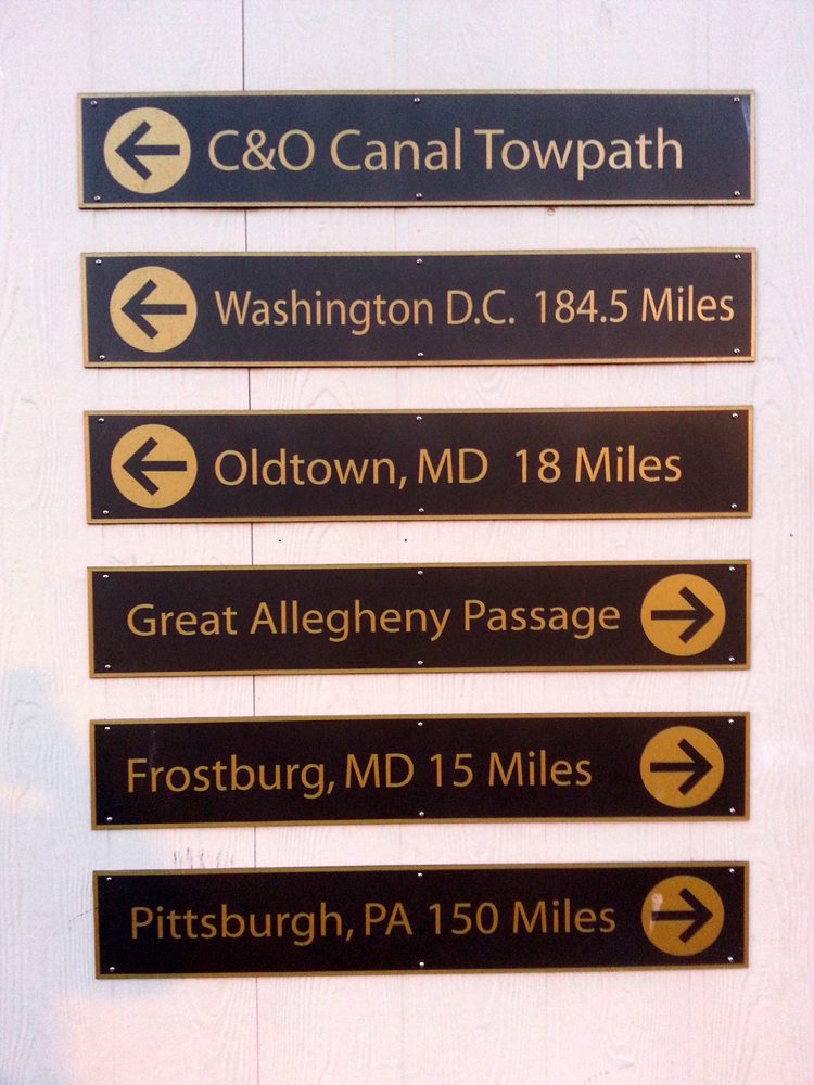
The directional sign gives approximate distance that can be traveled from this point and along trails connecting with Cumberland. Whether it be Washington, DC, 184.5 miles away; Oldtown, Maryland, 18 miles away, or Frostburg 15 miles in the opposite direction; or Pittsburgh 150 miles west.